Oceanus Intersects 67.6 Meters of 1.49 g/t Gold Equivalent Consisting of 1.24 g/t Gold and 19.1 g/t Silver at its El Tigre Property in Sonora, Mexico
May 25, 2017HALIFAX, NOVA SCOTIA – May 25, 2017 – Oceanus Resources Corporation (TSXV:OCN and OTCQB:OCNSF) ("Oceanus" or the “Company”) reports additional assay results from the 2017 diamond drilling program on its 100% owned El Tigre Property in Sonora, Mexico. Highlights from the drilling include the following:
- Hole ET-17-133 – 67.6 meters of 1.49 g/t gold equivalent from 78.5 meters to 146.1 meters consisting of 1.24 g/t gold and 19.1 g/t silver, including 23.4 meters of 3.31 g/t gold equivalent consisting of 2.77 g/t gold and 40.5 g/t silver
- Hole ET-17-135 – 37.7 meters of 0.78 g/t gold equivalent from 71.9 meters to 109.6 meters consisting of 0.62 g/t gold and 12.4 g/t silver, including 18.8 meters of 1.16 g/t gold equivalent consisting of 0.91 g/t gold and 18.9 g/t silver; and 8.4 meters of 1.95 g/t gold equivalent from 215.3 meters to 223.7 meters consisting of 1.52 g/t gold and 32.4 g/t silver
- Hole ET-17-140 – 9.0 meters of 1.86 g/t gold equivalent from 35.0 meters to 44.0 meters consisting of 0.18 g/t gold and 125.5 g/t silver, including 1.5 meters of 9.54 g/t gold equivalent consisting of 0.43 g/t gold and 683.2 g/t silver, in a step out hole approximately 500 meters to the south of the Main Deposit past Gold Hill (see drill hole location map at Appendix B)
The true width has not been calculated for the intercepts, but true width is generally estimated at 75-90% of drilled width. The gold equivalent ratio is based on a gold-to-silver price ratio of 75:1.
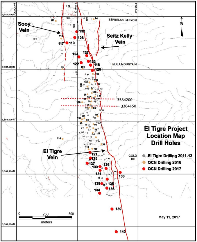
The new assay results are for drill holes ET-17-123 to ET-17-140. Refer to the Oceanus news releases dated September 14, 2016, October 18, 2016, December 14, 2016 and March 6, 2017 for the assay results for the previous drill holes. A map of a portion of the El Tigre Property is attached as Appendix A, a drill hole location map is attached as Appendix B, a table of significant drill intersections is attached as Appendix C and the drill hole location table is attached as Appendix D.
Glenn Jessome, President and CEO of Oceanus reports, “The Oceanus drilling has expanded and supports the continuity of the vein and alteration zone between the El Tigre Camp and the south end of Gold Hill, which is a distance of approximately 1,800 meters. The vein and alteration zone remains open along strike to the south, north and at depth. Furthermore, with hole ET-17-133 we have identified a possible new high grade zone at Gold Hill. With holes ET-17-139 and ET-17-140 we have extended the strike length to the south by approximately 500 meters. These drill results further support wide zones of precious metals mineralization that demonstrate potential as a bulk-tonnage target.”
El Tigre Drilling Program
Oceanus has completed the 2016-17 infill drilling program at El Tigre with a total of 62 diamond drill holes totalling 11,923.1 meters. The purpose of this drill program was to support a NI 43-101 resource estimation for the El Tigre Property. The results from the Oceanus drilling, prior drilling and other data will be incorporated into the resource estimation to be completed by P&E Mining Consultants Inc. by the end of June, 2017.
In particular, the drill program was designed to achieve the following objectives at El Tigre (see map at Appendix A);
- twin several legacy drill holes at the Main Deposit;
- infill the central area of the Main Deposit;
- infill the 500 meter gap along strike at the Main Deposit to the north between La Mula and the Camp;
- infill the 200 meter gap along strike at the Main Deposit to the south at Gold Hill;
- test for a southern strike extension to the south of Gold Hill; and
- test several of the veins to the north of the Main Deposit (Fundadora and Protectora).
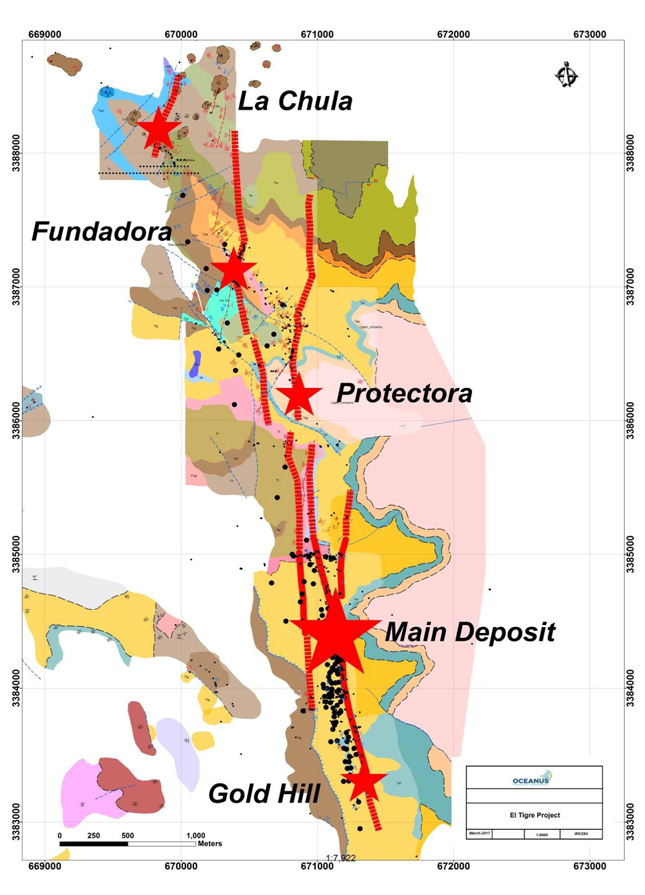
Prospecting Work to the North at Protectora, Fundadora and La Chula
Field mapping and prospecting surveys are in progress along the Protectora vein system located approximately 1.5 kilometers to the north of the El Tigre camp (see map at Appendix A). Oceanus drill holes ET-17-141 to ET-17-144 have been completed at Protectora and assay results are pending (see drill hole location table at Appendix D). At Protectora quartz vein and stockwork zones are located within an advanced argillic alteration zone. Gold and silver mineralization was discovered along the Protectora vein and stockwork zone in diamond drill holes by El Tigre Silver Corp. in 2013 (hole ET-13-019 intersected 2 meters of 1.41 g/t gold and 421.7 g/t silver from 86.0 meters to 88.0 meters).
At the Fundadora vein system field mapping and prospecting surveys are also in progress (see map at Appendix A).
Recent field mapping and prospecting surveys have identified newly discovered mineralization, which has been named La Chula vein system (see map at Appendix A). An extensive mapping and prospecting program is now being carried out at La Chula.
El Tigre Property
The El Tigre Property lies at the northern end of the Sierra Madre gold belt which hosts many of the larger multi-million ounce epithermal gold and silver deposits including Ocampo, Pinos Altos, Dolores and Palmarejo. In 1896, gold was first discovered on the property in the Gold Hill area and mining started with the Brown Shaft in 1903. The focus soon changed to mining high-grade silver veins in the area with the majority of the production coming from the El Tigre vein. Underground mining on the El Tigre vein extended 1,450 meters along strike and mined on 14 levels to a depth of 450 meters. By the time the mine closed in 1938, it is reported to have produced a total of 353,000 ounces of gold and 67.4 million ounces of silver from 1.87 million tons (Craig, 2012).
The El Tigre Property is approximately 35 kilometers long and comprises 21,842.78 hectares. The El Tigre gold and silver deposit is related to a series of high-grade epithermal veins controlled by a north-south trending structure cutting across the andesitic and rhyolitic tuffs of the Sierra Madre Volcanic Complex within a broad gold and silver mineralized prophylitic alternation zone. The veins dip steeply to the west and are typically 1 meter wide but locally can be up to 5 meters in width. The veins, structures and mineralized zones outcrop on surface and have been traced for a distance of 5.3 kilometers along strike. Historical mining and exploration activities focused on a 1.5 kilometer portion of the southern end of the deposits, principally on the El Tigre, Seitz Kelly and Sooy veins. Four veins in the north (Aguila, Escondida, Fundadora and Protectora) were explored with only limited amounts of production.
Lab Preparation and Assay
The diamond drill core (HQ size) is geologically logged, photographed and marked for sampling. When the sample lengths are determined, the full core is sawn with a diamond blade core saw with one-third of the core being bagged and tagged for assay. The remaining two-thirds portion is returned to the core trays for storage and/or for metallurgical test work.
The sealed and tagged sample bags are transported to the ActLabs facility in Zacatecas, Mexico. ActLabs crushes the samples and prepares 200-300 gram pulp samples with ninety percent passing Tyler 150 mesh (106μm). The pulps are assayed for gold using a 50 gram charge by fire assay (Code 1A2-50) and over limits greater than 10 grams per tonne are re-assayed using a gravimetric finish (Code 1A3-50). Silver and multi- element analysis is completed using total digestion (Code 1F2 Total Digestion ICP).
Quality Assurance / Quality Control and Data Verification
Quality assurance and quality control ("QA/QC") procedures monitor the chain-of-custody of the samples and includes the systematic insertion and monitoring of appropriate reference materials (certified standards, blanks and duplicates) into the sample strings. The results of the assaying of the QA/QC material included in each batch are tracked to ensure the integrity of the assay data. All results stated in this announcement have passed Oceanus’ QA/QC protocols.
Qualified Person
David R. Duncan, P. Geo., V.P. Exploration of the Company, is the Qualified Person for Oceanus as defined under National Instrument 43-101. Mr. Duncan has reviewed and approved the scientific and technical information in this press release and has reviewed the Technical Report.
About Oceanus Resources Corporation
Oceanus Resources Corporation is a gold exploration company operating in Mexico. Oceanus is managed by a team of mine finders with extensive experience in exploring and developing large hydrothermal gold projects in Mexico. Oceanus is currently drilling and exploring the El Tigre Property in the Sierra Madre Occidental.
For further information, please contact:
Glenn Jessome President and CEO 902 492 0298
jessome@oceanusresources.ca
CAUTIONARY STATEMENT:
Neither TSX Venture Exchange nor its Regulation Services Provider (as that term is defined in the policies of the TSX Venture Exchange) accepts responsibility for the adequacy or accuracy of this release.
This News Release includes certain “forward-looking statements”. All statements other than statements of historical fact included in this release, including, without limitation, statements regarding potential mineralization, resources and reserves, the ability to convert inferred resources to indicated resources, the ability to complete future drilling programs and infill sampling, the ability to extend resource blocks, the similarity of mineralization at El Tigre to the Ocampo mine, exploration results, and future plans and objectives of Oceanus, are forward-looking statements that involve various risks and uncertainties. Forward-looking statements are frequently characterized by words such as “may”, “is expected to”, “anticipates”, “estimates”, “intends”, “plans”, “projection”, “could”, “vision”, “goals”, “objective” and “outlook” and other similar words. Although Oceanus believes the expectations expressed in such forward-looking statements are based on reasonable assumptions, there can be no assurance that such statements will prove to be accurate and actual results and future events could differ materially from those anticipated in such statements. Important factors that could cause actual results to differ materially from Oceanus’s expectations include risks and uncertainties related to exploration, development, operations, commodity prices and global financial volatility, risk and uncertainties of operating in a foreign jurisdiction as well as additional risks described from time to time in the filings made by Oceanus with securities regulators.
APPENDIX A
El Tigre Property Map
APPENDIX B
El Tigre Drill Hole Location Map
APPENDIX C
El Tigre Drilling Results
| Hole ID | Section | Comment | From (m) |
To (m) |
Length (m) |
Au (g/t) |
Ag (g/t) |
AuEq(2) (g/t) |
|---|---|---|---|---|---|---|---|---|
| ET-17-123 | 4550 | 76.4 | 80.6 | 4.2 | 0.42 | 0.8 | 0.43 | |
| and | 133.5 | 149.5 | 16.0 | 0.20 | 13.5 | 0.38 | ||
| ET-17-124 | 4600 | 64.5 | 82.7 | 18.2 | 0.23 | 87.3 | 1.39 | |
| and | 94.8 | 120.6 | 25.8 | 0.41 | 20.9 | 0.69 | ||
| ET-17-125 | 3700 | 13.9 | 19.1 | 5.3 | 0.74 | 0.5 | 0.75 | |
| and | 58.7 | 62.0 | 3.4 | 0.42 | 33.0 | 0.86 | ||
| and | 134.0 | 142.2 | 8.2 | 0.37 | 37.1 | 0.87 | ||
| and | 189.9 | 194.0 | 4.2 | 0.12 | 18.1 | 0.36 | ||
| ET-17-126 | 3600 | 4.5 | 23.0 | 18.5 | 0.17 | 72.1 | 1.13 | |
| including | 15.8 | 21.5 | 5.8 | 0.48 | 182.8 | 2.92 | ||
| and | 69.0 | 75.0 | 6.1 | 0.39 | 1.2 | 0.40 | ||
| and | 87.0 | 105.0 | 18.0 | 0.35 | 32.3 | 0.78 | ||
| and | 112.0 | 118.0 | 6.0 | 0.19 | 11.3 | 0.34 | ||
| ET-17-127 | 4600 | 35.0 | 58.6 | 23.6 | 0.35 | 27.9 | 0.72 | |
| including | 51.1 | 52.7 | 1.6 | 1.30 | 395.9 | 6.57 | ||
| and | 152.3 | 161.7 | 9.4 | 0.23 | 14.9 | 0.42 | ||
| ET-17-128 | 4775 | 86.4 | 112.2 | 25.8 | 0.63 | 28.0 | 1.00 | |
| including | 100.4 | 105.1 | 4.7 | 1.06 | 106.6 | 2.48 | ||
| ET-17-130 | 3550 | 53.8 | 55.7 | 1.9 | 0.34 | 11.9 | 0.49 | |
| ET-17-131 | 3550 | 58.0 | 67.3 | 9.3 | 0.74 | 9.1 | 0.86 | |
| and | 77.9 | 86.3 | 8.4 | 0.27 | 2.7 | 0.30 | ||
| and | 142.5 | 147.0 | 4.5 | 0.80 | 74.6 | 1.80 | ||
| and | 178.0 | 202.2 | 24.2 | 0.35 | 22.0 | 0.65 | ||
| ET-17-132 | 4900 | 37.5 | 48.2 | 10.7 | 0.20 | 22.1 | 0.50 | |
| OPEN STOPE | 48.2 | 50.6 | 2.4 | El Tigre Vein | ||||
| and | 53.0 | 68.0 | 15.0 | 0.33 | 10.9 | 0.47 | ||
| ET-17-133 | 3500 | 65.4 | 68.4 | 3.0 | 0.98 | 1.0 | 0.99 | |
| and | 78.5 | 146.1 | 67.6 | 1.24 | 19.1 | 1.49 | ||
| including | 78.5 | 90.3 | 11.9 | 0.63 | 1.3 | 0.65 | ||
| including | 97.5 | 120.9 | 23.4 | 2.77 | 40.5 | 3.31 | ||
| and | 137.0 | 146.1 | 9.1 | 0.29 | 4.7 | 0.35 | ||
| and | 156.9 | 160.0 | 3.1 | 0.48 | 0.7 | 0.49 | ||
| ET-17-134 | 3300 | 98.2 | 105.5 | 7.3 | 0.62 | 9.6 | 0.75 | |
| and | 133.2 | 147.5 | 14.3 | 1.01 | 0.5 | 1.02 | ||
| including | 134.0 | 135.8 | 1.8 | 6.33 | 2.1 | 6.36 | ||
| and | 223.4 | 226.1 | 2.7 | 0.50 | 0.6 | 0.51 | ||
| and | 239.9 | 242.0 | 2.1 | 1.06 | 80.6 | 2.13 | ||
| ET-17-135 | 3450 | 71.9 | 109.6 | 37.7 | 0.62 | 12.4 | 0.78 | |
| including | 77.6 | 96.4 | 18.8 | 0.91 | 18.9 | 1.16 | ||
| and | 121.4 | 134.3 | 13.0 | 0.60 | 12.9 | 0.77 | ||
| and | 140.3 | 154.6 | 14.3 | 0.68 | 4.7 | 0.74 | ||
| and | 215.3 | 223.7 | 8.4 | 1.52 | 32.4 | 1.95 | ||
| ET-17-136 | 3350 | 26.0 | 44.0 | 18.0 | 0.94 | 3.5 | 0.99 | |
| and | 137.0 | 146.5 | 9.5 | 1.57 | 3.1 | 1.62 | ||
| and | 155.4 | 164.8 | 9.4 | 0.40 | 0.5 | 0.41 | ||
| and | 174.0 | 180.0 | 6.0 | 0.35 | 0.8 | 0.36 | ||
| and | 187.1 | 189.5 | 2.4 | 0.34 | 19.3 | 0.59 | ||
| and | 195.5 | 206.0 | 10.5 | 0.33 | 0.9 | 0.34 | ||
| ET-17-137 | 3600 | 98.5 | 129.5 | 31.0 | 0.41 | 1.3 | 0.43 | |
| 145.2 | 175.3 | 30.1 | 0.38 | 13.0 | 0.55 | |||
| 244.6 | 247.4 | 2.8 | 0.13 | 17.7 | 0.36 | |||
| OPEN STOPE | 263.1 | 268.6 | 5.5 | |||||
| 268.6 | 276.1 | 7.5 | 0.32 | 1.3 | 0.33 | |||
| ET-17-138 | 3400 | 20.0 | 25.0 | 5.0 | 0.42 | 0.7 | 0.43 | |
| and | 66.7 | 83.4 | 16.8 | 0.21 | 6.9 | 0.31 | ||
| and | 103.1 | 104.6 | 1.5 | 0.46 | 1.2 | 0.48 | ||
| and | 115.6 | 118.4 | 2.8 | 0.34 | 1.0 | 0.35 | ||
| and | 178.0 | 185.0 | 7.0 | 0.24 | 1.2 | 0.26 | ||
| and | 238.0 | 246.3 | 8.3 | 0.28 | 5.1 | 0.35 | ||
| ET-17-139 | 3150 | 10.6 | 15.8 | 5.2 | 0.96 | 1.7 | 0.98 | |
| ET-17-140 | 2950 | 35.0 | 44.0 | 9.0 | 0.18 | 125.5 | 1.86 | |
| including | 36.5 | 38.0 | 1.5 | 0.43 | 683.2 | 9.54 |
Notes:
- True width has not been calculated for each individual intercept, but true width is generally estimated at 75-90% of drilled width. Metallurgical recoveries and net smelter returns are assumed to be 100%
- Gold Equivalent ratio based on gold to silver price ratio of 75:1 Ag:Au.
APPENDIX D
El Tigre 2017 Drill Hole Location Table
| Hole ID | Northing | Easting | Elevation | Azimuth | Dip | Length |
|---|---|---|---|---|---|---|
| ET-17-134 | 3383300 | 671185 | 1940 | 90 | -50 | 302.0 |
| ET-17-135 | 3383450 | 671232 | 1994 | 90 | -45 | 223.7 |
| ET-17-136 | 3383350 | 671239 | 1960 | 90 | -45 | 221.0 |
| ET-17-137 | 3383600 | 671099 | 1988 | 90 | -55 | 144.2 |
| ET-17-138 | 3383400 | 671220 | 1973 | 90 | -60 | 275.4 |
| ET-17-139 | 3383150 | 671303 | 1830 | 90 | -45 | 116.0 |
| ET-17-140 | 3382950 | 671313 | 1797 | 90 | -45 | 212.0 |
| ET-17-141 | 3387684 | 670011 | 1927 | 90 | -45 | 299.0 |
| ET-17-142 | 3387700 | 670277 | 1939 | 90 | -45 | 247.4 |
| ET-17-143 | 3385650 | 670740 | 1840 | 90 | -45 | 232.0 |
| ET-17-144 | 3386645 | 670680 | 2040 | 90 | -45 | 224.0 |
© 2026 Silver Tiger Metals Inc.|TSX:SLVR, OTCQX:SLVTF, FR:10C|Disclaimer
Disclaimer:
User Agreement
The following terms and conditions, along with all other terms and legal notices located on this https://silvertigermetals.com website (collectively, "Terms"), govern your use of this https://silvertigermetals.com website (the "Website"). If you do not understand and agree to be bound by all Terms, do not use this Website. Your use of this Website at any time constitutes a binding agreement by you to abide by these Terms.
Certain material found on this Website is protected by copyright. Certain names, graphics, logos, icons, designs, words, titles or phrases on this Website may constitute trade names, trademarks or service marks of Silver Tiger Metals Inc. ("Silver Tiger") or other entities. Trademarks may be registered in Canada and in other countries, as applicable. The display of trademarks on pages at this Website does not imply that a licence of any kind has been granted.
Although care has been taken in preparing and maintaining the information and materials contained on this Website, they are provided on an "as is" basis, without warranty of any kind, either express or implied, with respect to the accuracy or completeness of the information and Silver Tiger does not assume any responsibility or liability whatsoever for publishing them herein. In using this Website, you agree that Silver Tiger shall not be liable for any damages whatsoever (including indirect, incidental, special, punitive or consequential damages and loss of profits, opportunities or information) arising from (a) your use of or reliance on information contained on this Website; (b) any inaccuracy or omission in such information or failure to keep the information current; (c) use of any third-party web sites linked or referred to in this Website; (d) any delays, inaccuracies or errors in, or in the transmission of, any stock price quotes or historical price data; (e) any Internet software used in connection with this Website or computer viruses or other destructive programs encountered as a result of using this Website; and (f) any other matter connected with the Website, even if Silver Tiger is made aware of the possibility of such claims, damages or losses.
This Website contains links to, or feeds from, sites that Silver Tiger does not maintain. Silver Tiger assumes no responsibility for the contents of third-party sites accessed through links on, or otherwise incorporate in, this Website. Access to or information from such third-party sites is provided for your convenience only. Silver Tiger does not monitor or endorse such third-party sites.
This Website is not to be construed as a form of promotion, an offer to sell securities or as a solicitation to purchase our securities. This Website has been produced as a source of general information only.
Please note that this Website contains "forward-looking information", within the meaning of applicable Canadian securities legislation. Forward-looking information includes, but is not limited to, information with respect to our plans respecting our mineral projects and our other key mineral properties and the ability to secure and maintain required permits for such projects and properties, exploration expenditures and activities and the possible success of such exploration activities, the estimation of mineral reserves and resources, the realization of mineral estimates, the timing and amount of estimated future production, costs of production, capital expenditures, costs and timing of the development of new deposits, mineral pricing, mine life projections, the availability of third-party concentrate, business and acquisition strategies and the timing and possible outcome of pending litigation. Often, but not always, forward-looking information can be identified by the use of words like "plans", "expects", "estimates", "forecasts", "intends", "understands", "anticipates", and similar expressions. Forward-looking information is based on the opinions and estimates of management as of the date such information is provided and is subject to known and unknown risks, uncertainties and other factors that may cause our actual results, level of activity, performance or achievements to be materially different from those expressed or implied by such forward-looking information, including risks associated with the mining industry such as economic factors (including future commodity prices, currency fluctuations and energy prices), failure of plant, equipment, processes and transportation services to operate as anticipated, dependence on key personnel and employee relations, environmental risks, government regulation, actual results of current exploration activities, possible variations in ore grade or recovery rates, permitting timelines, capital expenditures, reclamation activities, land titles, and social and political developments and other risks of the mining industry. Although we have attempted to identify important factors that could cause actual results to differ materially from those contained in forward-looking information, there may be other factors that cause results not to be as anticipated, estimated or intended. There can be no assurance that forward-looking information will prove to be accurate, as actual results and future events could differ materially from those anticipated in such information. Accordingly, readers should not place undue reliance on forward-looking information. We do not undertake to update any forward-looking information, except as required by applicable securities laws, or to comment on analyses, expectations or statements made by third parties in respect of us, our financial or operating results or our securities.
Cautionary Note to US Investors
The disclosure on this Website has been prepared in accordance with the requirements of Canadian securities laws, which differ from the requirements of United States securities laws. Disclosure, including scientific or technical information, has been made in accordance with Canadian National Instrument 43-101 -- Standards of Disclosure for Mineral Projects ("NI 43-101"). NI 43-101 is a rule developed by the Canadian Securities Administrators that establishes standards for all public disclosure an issuer makes of scientific and technical information concerning mineral projects. As a result, information contained on this Website containing descriptions of the mineral properties or estimates of mineral reserves or resources of Silver Tiger is not comparable to similar information disclosed by U.S. companies in reports filed with the SEC.
For example, the terms "measured mineral resources", "indicated mineral resources", "inferred mineral resources", "proven mineral reserves" and "probable mineral reserves" are used on this Website to comply with the reporting standards in Canada. While those terms are recognized and required by Canadian regulations, the SEC does not recognize them.
Under the rules and regulations of the SEC set forth in Industry Guide 7, a U.S. company may only disclose estimates of proven and probable mineral reserves, and may not disclose estimates of any classification of mineral resources. In addition, the definitions of proven and probable mineral reserves used in NI 43-101 differ from the definitions in the SEC Industry Guide 7. Under United States standards, mineralization may not be classified as a "reserve" unless the determination has been made that the mineralization could be economically and legally produced or extracted at the time the reserve determination is made. Investors are cautioned not to assume that all or any part of the mineral deposits in these categories will ever be converted into mineral reserves. Any estimate of mineral reserves or resources has a great amount of uncertainty as to its existence, and great uncertainty as to its economic and legal feasibility with estimates of mineral resources having a greater degree of uncertainty. It cannot be assumed that all or any part of measured mineral resources, indicated mineral resources or inferred mineral resources will ever be upgraded to a mineral reserve or mined. Further, in accordance with Canadian rules, estimates of inferred mineral resources cannot form the basis of feasibility or other economic studies. Investors are cautioned not to assume that any part of the reported measured mineral resources, indicated mineral resources, or inferred mineral resources on this Website will ever be classified as a reserve. Disclosure of "contained ounces" is permitted disclosure under Canadian regulations; however, the SEC normally only permits issuers to report mineralization that does not constitute reserves as in place tonnage and grade without reference to unit measures.